Petroleum Geology
for Non-Geologists
eLearning Course
Petroleum geology is at the forefront of the oil and gas industry and either directly or indirectly affects every role. The topic has become even more important with the emergence of “unconventional” development because most people don’t fully understand the unique characteristics and challenges of unconventional development.
The subject of petroleum geology has long been considered impenetrable without a geology or geophysics degree. We’ve changed that. This course will give you an intermediate understanding of the topic with only a beginner’s level of difficulty. We make extensive use of photos, graphics, videos, animations, real-world analogies, self-explore options and interactive exercises to explain complicated topics in an easy-to-understand way. The course contains several drill-down options for those that are interested in learning more about a topic.
For one low price, you will have access to 15 modules that will progressively build the knowledge you need to understand oil and gas exploration. Modules 1-8 explain the geological processes lead to the development of a “petroleum system” in the subsurface. Modules 9 and 10 address oil and gas business and economic considerations. Modules 11-15 describe the technologies and methods used to explore for oil and gas.
The course is conveniently divided into short sections that are mostly 15-25 minutes long (some modules have multiple sections). The course is about 8-10 hours long, plus an extra 20-30 minutes if you elect to take the final exam that is required to earn a completion certificate (there are no test questions on optional drill-down topics). You can learn more about each module by clicking on the module titles below.
You’ll be glad that you took this course. It will not only teach you about petroleum geology but will also shed more light on the fascinating world around you!
Modules
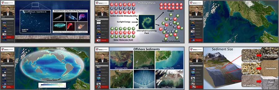
This module describes what the term “organic” means and how that term relates to hydrocarbons such as oil and gas. We dispel a common myth about the source of oil and gas and describe the seemingly-unlikely organisms that are the actual source. These organisms still exist today and we’ll discuss the environments where they thrive and how their remains can be preserved by sediments. This will be important in later sections when we look back in time to see where organic remains may have been deposited and preserved in the past. Many of those deposits are sources of oil and gas today.
Duration: Approximately 13 minutes, depending on user pace.
Learning Objectives: Upon successful completion of this module, you will be able to:
- Describe the organisms that are the primary source of oil and gas
- Explain how organisms generate organic debris that could lead to the eventual formation of oil and gas
- Convey how organic debris can be preserved if covered by sediments
- Name the type of sediments that can best preserve organic debris and the type of organic source rock that those sediments create
- Identify the types of areas where organisms thrive, and how that could provide clues where source rock may exist
Prerequisites: None
Advance Preparation: None
Program Level: Non-technical
Format: Prerecorded narrator with supporting visuals. User controls course pace.
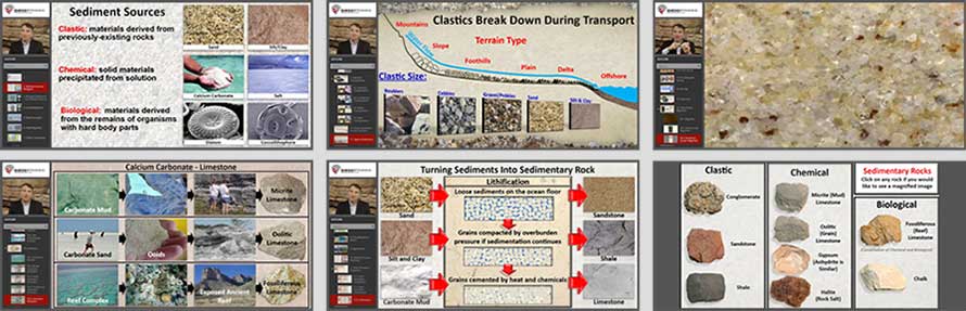
Almost all oil and gas is found in “sedimentary” rock, and this module explains the natural processes that create sediments, as well as how those sediments become rock. You will learn about the major categories of sediments and will see magnified images of rock types to see how different they can be, and how they therefore serve differing roles in oil and gas. The material never becomes difficult or tedious, yet you will finish with a decent understanding of the rock types that are important to oil and gas such as shale, sandstone, limestone and halite/salt.
Duration: Approximately 36 minutes, depending on user pace. In two modules: 2A (24 minutes) and 2B (12 minutes).
Learning Objectives: Upon successful completion of this module, you will be able to:
-
List types of sediments
-
Explain how sediments are deposited
-
Describe how sediments can become sedimentary rock
-
Name ways that sedimentary rocks can differ in characteristics and how those characteristics cause rocks to serve different roles in oil and gas
-
Recognize types of sedimentary rock important to oil and gas
Prerequisites: Module 1
Advance Preparation: None
Program Level: Non-technical
Format: Prerecorded narrator with supporting visuals. User controls course pace.
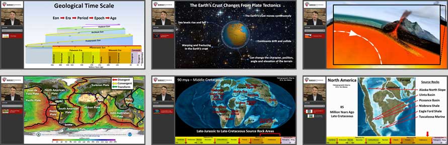
Oil and gas comes from source rock that is up to 500 million years old. The surface of the Earth has changed radically over that period of time due to a process called plate tectonics, so geoscientists must understand how the Earth has changed to understand where source rock may have been created in the past and where those sources lie hidden beneath the surface today. We’ll discuss geological time, plate tectonics, and will take a look back in time to see how the Earth has changed. This subject is fascinating even if you’re not interested in oil and gas.
Duration: Approximately 40 minutes, depending on user pace. In two modules: 3A (17 minutes) and 3B (23 minutes).
Learning Objectives: Upon successful completion of this module, you will be able to:
- Explain the concept of geological time and the period in Earth’s history that is of most interest from an oil and gas standpoint
- List ideal locations and conditions for oil and gas source-rock creation
- Describe how the Earth’s crust has changed radically over geological time and how understanding the Earth’s history is important for identifying where source rock may have been created in the past
- Name periods of time when source-rock creation was particularly high and where the most-productive areas were at that time
- Convey where some of the major source rock deposits from the past are located on the Earth’s surface today
Prerequisites: Module 1-2
Advance Preparation: None
Program Level: Non-technical
Format: Prerecorded narrator with supporting visuals. User controls course pace.
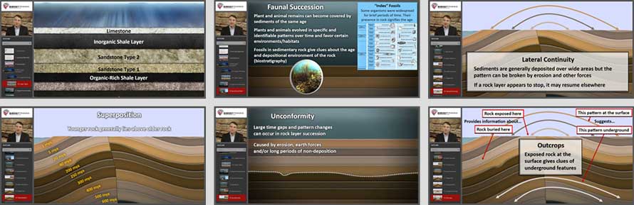
Sedimentary rocks are created by natural processes but are also altered by natural processes. An understanding of these processes sometimes allows geoscientists to assemble a great deal of information about the subsurface from small surface clues. In this section, we briefly discuss general principles that geoscientists follow in evaluating rock formations. You’ll never again think that rocks are boring when you understand the rich history that they can reveal!
Duration: Approximately 10 minutes, depending on user pace.
Learning Objectives: Upon successful completion of this module, you will be able to:
- Describe why sediment deposits differ over time, creating rock layers with varying characteristics
- Discuss how continued accumulation of sediments can cause older rock layers to become buried deeply underground
- List ways that rock layers can be changed over time and how geoscientists can identify some of the changes that have occurred
- Explain how fossils can be used to estimate the age of rock layers and the conditions in which the layers were deposited
- Convey how exposed rock at the surface can provide important clues about the structure and characteristics of rock layers underground
Prerequisites: Module 1-3
Advance Preparation: None
Program Level: Non-technical
Format: Prerecorded narrator with supporting visuals. User controls course pace.
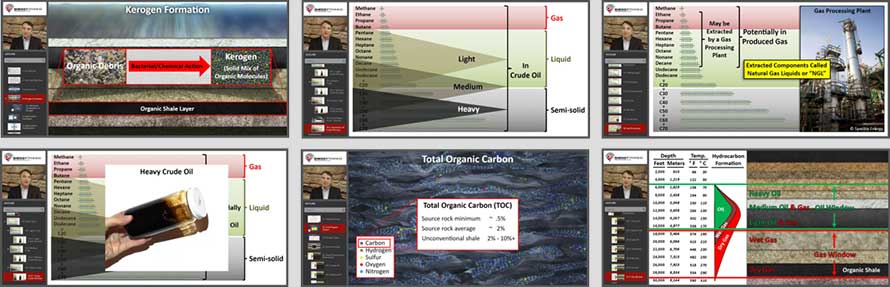
Oil and gas are composed of “hydrocarbon” molecules made of hydrogen and carbon atoms. In this module, we will painlessly explain hydrocarbon types including hydrocarbon gases, condensate, natural gas liquids (LGL’s), light oil, medium oil and heavy oil. We’ll discuss how these molecules are formed from organic content in source rock as it becomes buried deeply underground. This basic knowledge of hydrocarbon characteristics will be useful during other parts of the course but is also key to understanding other industry topics such as crude oil quality and gas processing.
Duration: Approximately 20 minutes, depending on user pace.
Learning Objectives: Upon successful completion of this module, you will be able to:
- Describe how kerogen is formed and serves as the first stage of conversion from organic debris to oil and gas
- Explain how deep burial exposes kerogen to heat and pressure over time and can cause kerogen to break into oil and gas molecules
- Summarize the chemistry and behavior of hydrocarbons and the differences between dry gas, rich gas, light oil, medium oil and heavy oil
- Explain how fossils can be used to estimate the age of rock layers and the conditions in which the layers were deposited
- Convey how burial depth impacts the creation of oil and gas as well as the type of molecules that are formed
Prerequisites: Module 1-4
Advance Preparation: None
Program Level: Non-technical
Format: Prerecorded narrator with supporting visuals. User controls course pace.
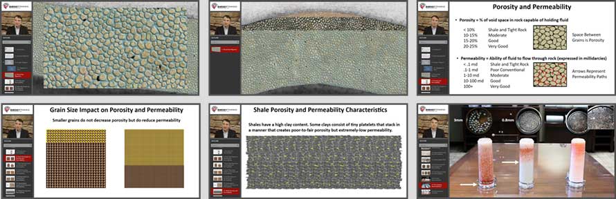
Many people don’t realize that oil and gas has not “conventionally” been produced from the same source rock in which it was created. That rock is good for preserving organic remains until it can mature into oil and gas, but it can be exceedingly-difficult to produce from. Fortunately, some oil and gas escapes the source rock and migrates underground. In this module, we discuss how that migration occurs and how migrating oil and gas can accumulate in better-quality “reservoir” rock in trap-like structures. We discuss the characteristics that make good “reservoir” rock and contrast it with the poor characteristics of source rock and tight rock that are the subject of “unconventional” development. We finish with a cool demonstration that shows why rock quality is so important.
Duration: Approximately 15 minutes, depending on user pace.
Learning Objectives: Upon successful completion of this module, you will be able to:
- Discuss how some oil and gas can leave its source rock and migrate underground through rock pores
- Describe how buoyancy drives oil and gas in a generally-upward direction
- Explain how rock porosity, permeability and other factors impact the ability for oil and gas to migrate through rock and affect its migration route
- Convey how oil and gas can enter trap-like structures or features that block its flow and cause oil and gas to accumulate
Prerequisites: Module 1-5
Advance Preparation: None
Program Level: Non-technical
Format: Prerecorded narrator with supporting visuals. User controls course pace.
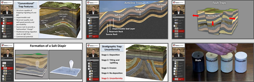
In this module, we explain types of underground features that can “trap” oil and gas. We show animations of how they are formed and how they trap migrating oil and gas. We also show photos of natural features such as anticlines, faults, reefs, deltas and streambeds to demonstrate how these features would be structured underground. An important takeaway from this section is that oil and gas is not found in underground caves or caverns – it’s actually within the rock between the pore spaces. We do a demonstration of reservoir rock and seal rock characteristics by putting water drops on the rock so that you can how the water behaves. The water can demonstrate rock characteristics that we can’t observe with our eyes!
Duration: Approximately 29 minutes, depending on user pace. In two modules: 7A (15 minutes) and 7B (14 minutes).
Learning Objectives: Upon successful completion of this module, you will be able to:
- Describe the requisite elements of a “conventional” oil and gas trap including source, maturity, migration, reservoir and seal
- Retell a demonstration shown of how different types of rock have different roles in trapping oil and gas
- List different types of traps, how they are formed, and how they trap oil and gas
- Explain the difference between “conventional” and “unconventional” traps
Prerequisites: Module 1-6
Advance Preparation: None
Program Level: Non-technical
Format: Prerecorded narrator with supporting visuals. User controls course pace.
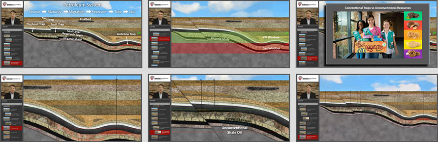
In this module, we bring together all of the petroleum geology elements discussed in prior modules to construct the “big picture” – the Total Petroleum System: source, maturity, migration, reservoir, trap and seal. By this time, you will have a solid understanding of petroleum geology elements and it will all make sense. You will finish this section with a thorough understanding of the difference between conventional traps and unconventional shale and tight rock. We will solidify that explanation with our “girl scout cookies” analogy. When we use that analogy in our live courses, a wave of understanding sweeps over listeners’ faces!
Duration: Approximately 14 minutes, depending on user pace.
Learning Objectives: Upon successful completion of this module, you will be able to:
- Explain the concept of a “total petroleum system” that includes all of the petroleum geology elements that come together over time to create an oil and gas accumulation
- Confidently describe the difference between conventional and unconventional development
- Describe factors supportive and unsupportive of unconventional development
- Describe factors supportive and unsupportive of unconventional development
- Follow and appreciate basic petroleum geology comments made by geoscientists and understand key terms that they use
Prerequisites: Module 1-7
Advance Preparation: None
Program Level: Non-technical
Format: Prerecorded narrator with supporting visuals. User controls course pace.

Exploration is not just a science – it’s a business! You can only work in areas where you can acquire “mineral rights,” you have to limit yourself to opportunities where you have a reasonable chance of generating a profit, and you have to do it in a volatile environment with price fluctuations and other risks and opportunities. In this module, we explain how oil and gas companies evaluate projects by projecting all cash inflows and outflows over the life of a project, including: all costs, the quantity and timing of production, product prices, mineral rights contract terms, and other factors. We explain why cash flows received or paid in the future are not as valuable as cash received or paid today, and we painlessly explain how future cash flows are therefore “discounted” to estimate the “net present value” of a project. Everyone should know these important business factors that drive the industry!
Duration: Approximately 25 minutes, depending on user pace.
Learning Objectives: Upon successful completion of this module, you will be able to:
- Recognize that business objectives make exploration much more challenging than just finding oil and gas
- List common costs incurred in oil and gas exploration and development
- Describe why the timing of revenues received and costs paid is important for estimating the value of a project
- Explain why mineral rights are required and how they are obtained through leasing and other forms of contract
- Summarize common mineral rights terms and how they impact project economic results
- Summarize common mineral rights terms and how they impact project economic results
Prerequisites: Module 1-8
Advance Preparation: None
Program Level: Non-technical
Format: Prerecorded narrator with supporting visuals. User controls course pace.

Exploration is an inherently risky business – you don’t know for sure what is in the ground and can drill a dry hole even if a prospect looks beautiful. However, dry holes are only part of the risk, and there are also many things that could turn out better than expected. In this module, we’ll discuss key risks and opportunities. Most projects have a range of potential outcomes (rather than just succeed or fail) so we’ll take a painless look at how decision trees are used to calculate a statistical “expected value” of a project based on its range of possibilities. We discuss common ways that oil and gas companies mitigate their risks. We finish by discussing all of the factors that have to be considered in choosing an exploration area and you’ll come to realize that it is VERY DIFFICULT for an oil and gas company to secure good exploration opportunities!
Duration: Approximately 27 minutes, depending on user pace.
Learning Objectives: Upon successful completion of this module, you will be able to:
- Describe key risks and opportunities involved in exploration and production
- Explain stages of cost commitment that progressively increase the amount of money at risk in an exploration project
- Sketch out a decision-tree diagram explaining how companies incorporate probabilities of various outcomes into investment decisions
- Summarize ways that companies mitigate their risk and leverage their opportunities by working with partners and taking other actions
- Relate how attractive and viable investment opportunities can be difficult to find after considering all of the risks and obstacles
Prerequisites: Module 1-9
Advance Preparation: None
Program Level: Non-technical
Format: Prerecorded narrator with supporting visuals. User controls course pace.
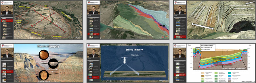
This section is both highly informative and entertaining. We examine an actual hydrocarbon-producing basin, discuss how it is structured, and show surface features that provide information about underground rock layers. We hypothetically discuss how geoscientists might choose to evaluate the basin if it was a “frontier” area that had never been explored, and then discuss frontier exploration tools. Although many of these tools employ sophisticated technology, we discuss them in an easy-to-understand way, including satellite imagery, gravity surveys and magnetic surveys. There are also examples of modeling and mapping. There are a few sections where you can choose to explore on your own.
Duration: Approximately 80 minutes, depending on user pace. In three modules: 11A (31 minutes), 11B (25 minutes), and 11C (25 minutes).
Learning Objectives: Upon successful completion of this module, you will be able to:
- Relate petroleum geology topics covered in prior modules to an actual petroleum-producing basin and recognize how those topics can be applied to better understand the basin
- Retell how it was demonstrated that surface features in the area combined with geological knowledge provide a substantial amount of information about the subsurface
- Explain how pre-existing information such as geological reports, well logs, well cores and seismic data is available for many areas and is a useful way to start in a new area
- Describe how a “frontier area” may have little pre-existing data available and geoscientists would start with cheap tools that provide information over a wide area to identify the most prospective areas for using more-expensive, higher-resolution tools
- Discuss some of the tools used in frontier exploration including mapping, stratigraphic analysis, satellite multi-spectral data, seep detection, gravity surveys and magnetic surveys
Prerequisites: Module 1-10
Advance Preparation: None
Program Level: Non-technical
Format: Prerecorded narrator with supporting visuals. User controls course pace.

In this module, we begin our discussion of seismic by describing seismic waves, how they travel, and how they reflect or refract at rock layer boundaries. We use simple, real-world examples that make seismic waves easy to understand and we have a couple of optional drill-down sections for those that want to learn more (P-wave propagation and acoustic impedance). You need a basic understanding of seismic waves in order to understand topics like seismic acquisition, processing and interpretation, which will follow in the next three modules. This section will not only help you understand oil and gas exploration, but it may also interest you to learn about cool natural phenomena that you witness every day and may not have noticed.
Duration: Approximately 32 minutes, depending on user pace, and assuming that optional sections are reviewed.
Learning Objectives: Upon successful completion of this module, you will be able to:
- List types of subsurface features – such as rock layers and trap structures – that can be identified by seismic imaging
- Discuss types of seismic waves and how they travel
- Describe the types of seismic waves that are useful for subsurface imaging
- Explain how changes in rock-layer characteristics can cause seismic waves to reflect at layer boundaries, and how those reflections can be used to identify the boundary locations
- Describe how offshore seismic differs from land seismic because the waves must pass through water
- Reinforce your seismic knowledge frequently by remembering examples given of how wave behavior is encountered in everyday life
Prerequisites: Module 1-11
Advance Preparation: None
Program Level: Non-technical
Format: Prerecorded narrator with supporting visuals. User controls course pace.
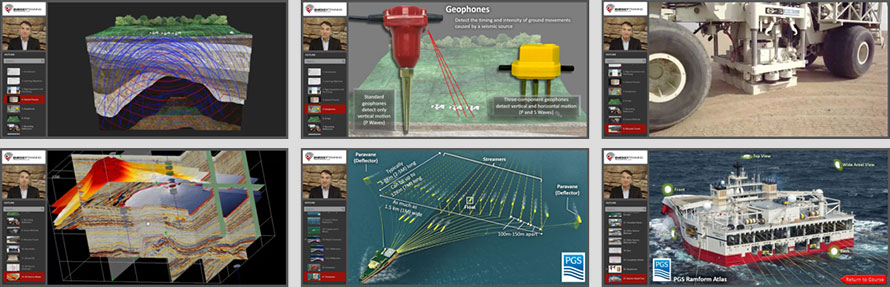
In this module, you will learn how seismic waves are created and how seismic reflections are detected. For onshore seismic, you will learn how shot holes and vibroseis trucks are used to generate source waves and how geophones are used to detect reflections. For offshore seismic, you will learn about seismic vessels and all of the components involved in towed streamer surveys. You will also learn about some of the peculiarities of recording offshore seismic. There will also be brief coverage of ocean-bottom surveys and working in shallow transition zones. There are several optional drill-down sections covering land seismic survey design, geophone design, vertical seismic profiling, micro-seismic and 4-D seismic.
Duration: Approximately 32 minutes, depending on user pace.
Learning Objectives: Upon successful completion of this module, you will be able to:
- Explain how vibroseis trucks and/or shot-hole charges are used to create seismic waves on land
- Describe how geophones are used to detect land seismic-wave reflections
- Describe the types of seismic waves that are useful for subsurface imaging
- State how the survey design and final imaging of a 2-D seismic survey differs from a 3-D survey
- Discuss how offshore seismic surveys are conducted and some of the complications involved
- Summarize other seismic methods sometimes used in oil and gas exploration
Prerequisites: Module 1-12
Advance Preparation: None
Program Level: Non-technical
Format: Prerecorded narrator with supporting visuals. User controls course pace.
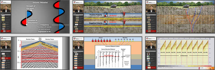
In this module, you will learn about the useful types of information contained in a recorded seismic wave and how that information is utilized during processing. We discuss how seismic information is convoluted with various types of noise and we discuss techniques such as “common midpoint gathering” that increase the useful signal and reduce the noise. You will see examples of both onshore and offshore raw “shot gathers” and we discuss common steps to get from a shot gather to a useful seismic image. We also discuss how seismic processing is correlated with other available information about an area, such as well logs.
Duration: Approximately 35 minutes, depending on user pace. In two modules: 14A (18 minutes) and 14B (17 minutes).
Learning Objectives: Upon successful completion of this module, you will be able to:
- Discuss how seismic data is recorded on trace lines and the information that can be obtained from those traces
- Summarize seismic wave amplitude, frequency and polarity and the information conveyed by those characteristics
- List types of seismic noise and convey how noise complicates processing
- Describe techniques to reduce seismic noise such as filtering and common midpoint gathers
- Recount an example shown of the key steps involved in seismic processing, beginning with a shot gather and ending with a processed image
Prerequisites: Module 1-13
Advance Preparation: None
Program Level: Non-technical
Format: Prerecorded narrator with supporting visuals. User controls course pace.
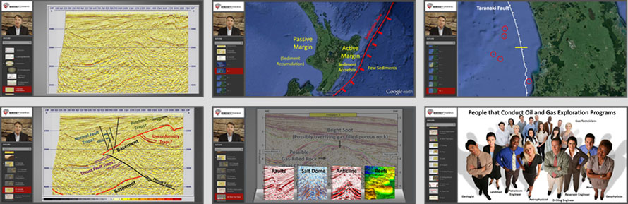
This module presents an interpretation of the major features in an example seismic image. The interpretation involves a discussion of features that an experienced geoscientist could learn just by looking at the image, and how that interpretation can be enhanced by using other knowledge of the area, such as tectonic history and logs from nearby wells. Seismic interpretation can be highly subjective and this exercise will NOT teach you how to become a seismic interpreter. However, all of the information taken together in this course should allow you to follow, with interest, a geoscientist describing a seismic image including the geological background, petroleum system elements, and project economics. The module also discusses “direct hydrocarbon indicators” that are sometimes visible on seismic. The module finishes with a summary of key exploration terms and describes the positions commonly involved in exploration (job titles and duties). There is an optional drill-down that allows you to look at other seismic images highlighting common trap types.
Duration: Approximately 22 minutes, depending on user pace.
Learning Objectives: Upon successful completion of this module, you will be able to:
- Relay how experienced geoscientists can identify geological features in seismic images that are difficult to perceive with an untrained eye.
- Discuss how other types of (non-seismic) data are commonly available enhance understanding of a seismic image.
- Retell a real-world example of the story behind a seismic image used in the course
- Define common exploration terms
- Name the types of positions involved in oil and gas exploration and their roles
Prerequisites: Module 1-14
Advance Preparation: None
Program Level: Non-technical
Format: Prerecorded narrator with supporting visuals. User controls course pace.
At the end of this course, users may complete an exam to test their understanding and retention of the course information.